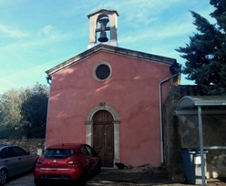
Chapelle Notre-Dame-du-Pays-Haut
|
Rougiers (Var)
Autres noms:
Saint-Honorat
Longitude:
5.855
, Latitude:
43.389
, Altitude:
387 m
localisation spatiale
Ancrage temporel
500
600
700
800
900
1000
1100
1200
1300
1400
1500
1600
1700
1800
1900
2000
Pas de datation répertoriée
Ressources répertoriées
--> chapelles.provence.free.fr
vue en 2016
© UMR CNRS/MCC 3495 MAP
max altitude 3156 m alt px = alt/20
comparatif altitude et orientation