chapelle de Charance
|
Gap (Hautes-Alpes)
Autres noms:
Chapelle Saint-Louis
Longitude:
6.058
, Latitude:
44.571
, Altitude:
919 m
localisation spatiale
+
-
OSM
geoportail
geoportail2
edifices
Leaflet
| ©
OpenStreetMap
contributors
Ancrage temporel
500
600
700
800
900
1000
1100
1200
1300
1400
1500
1600
1700
1800
1900
2000
3 date(s) répertoriée(s) - 3 source(s) - 3 divergence(s)
Ressources répertoriées
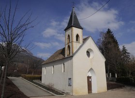
--> dignois.fr
--> www.diocesedegap.fr
--> www.patrimoine-religieux.fr
vue en 2018
© UMR CNRS/MCC 3495 MAP
max altitude 3156 m alt px = alt/20
comparatif altitude et orientation